For CEA media contact information, visit the Press Releases page.
Coalinga earthquake anniversary reminds Central Valley Californians that a ‘Big One’ could strike at any time
(SACRAMENTO) Today marks the 35th anniversary of the 1983 magnitude 6.7 Coalinga earthquake, which injured 94 people and caused millions of dollars in property damage. The epicenter was 7.5 miles northeast of Coalinga, about halfway between Los Angeles and San Francisco. It struck at 4:42 p.m. on May 2, 1983, and was felt from Los Angeles through Sacramento, and from the coast all the way to Las Vegas.
The Coalinga quake, which occurred on a previously unknown fault, resulted in $10 million in property damage (equivalent to about $25 million today). According to the American Red Cross, of the nearly 2,000 houses, apartments and mobilehomes damaged by the quake, 342 were virtually destroyed and 691 more had major damage.*
“No one knows when or where the next ’Big One’ will strike. It could happen today,” said California Earthquake Authority (CEA) CEO Glenn Pomeroy. “That’s why all Californians should prepare to survive and recover from California’s next damaging earthquake.”
After the 1983 Coalinga earthquake, California leaders saw a clear need to make earthquake insurance available to all residents. Still in place today, the 1985 “mandatory earthquake offer” law requires all home insurance companies in California to offer earthquake coverage. Most of California’s residential insurance market participants offer earthquake policies from the not-for-profit CEA, the country’s largest provider of residential earthquake insurance. CEA has lowered its rates four times by a combined 55 percent since it was established in 1996.
“While record numbers of Californians throughout the state are now purchasing CEA policies, only 3.4 percent of residential policyholders in Fresno County have purchased earthquake insurance. This is an economic catastrophe waiting to happen,” Pomeroy said. “Only a separate earthquake policy will pay to repair shake damage to houses, replace personal property, and cover costs to live and eat somewhere else if the home is not habitable.”
The greater southern Central Valley region—Fresno, Kern, Kings, Madera, Mariposa, Merced and Tulare counties—is ringed by faults, including the Garlock fault to the south, the faults of the Sierra Nevada to the east, and the dangerous San Andreas fault system to the west.
A 2017 study by the U.S. Geological Survey found that a portion of the San Andreas fault near the Tejon Pass could be overdue for a major earthquake. Earthquakes there happen about every 100 years, on average, with the last one—the magnitude 7.9 Fort Tejon quake—occurring in 1857, when there was almost no development in the area.
Learn more about local earthquake risk; explore CEA’s earthquake-insurance options for homeowners, mobilehome owners, condo-unit owners and renters; and learn about how homeowners can prepare their houses against earthquake damage at EarthquakeAuthority.com.
About CEA
The California Earthquake Authority (CEA) is a not-for-profit, privately funded, publicly managed organization that provides residential earthquake insurance and encourages Californians to reduce their risk of earthquake loss. Learn more at EarthquakeAuthority.com.
*The 2018 dollar amount was calculated using the California Bureau of Labor Statistics CPI inflation calculator, without adjusting for significant changes in the area’s population density, building types or other factors. Information about the 1983 Coalinga earthquake’s magnitude and resulting damage came from U.S. Geological Survey professional paper 1487 and the disaster assessment by the American Red Cross came from U.S. Geological Survey bulletin 1698 about 1983 earthquakes.
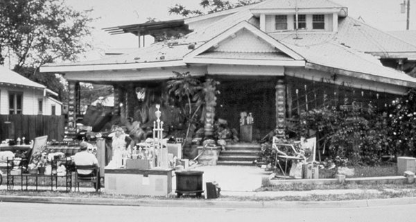
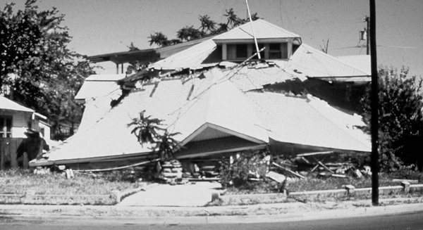
Images of the 1983 Coalinga earthquake
Photo 1 of 2: Single-family home damaged by the magnitude 6.7 earthquake in Coalinga on May 2, 1983. The quake inflicted severe damage to the unreinforced masonry porch, forcing the occupants to evacuate.
Photo credit: California Seismic Safety Commission.
Photo 2 of 2: Numerous aftershocks occurred within the next few days, causing portions of the already-weakened structure to collapse.
Photo credit: California Seismic Safety Commission.
For a high-resolution version of these images, contact Pamela Diaz.


